The maps below compare changing race/ethnicity patterns in the last decade, Census block by Census block in relation to current Congressional district boundaries in New York City.
In particular, the maps highlight the population changes in and around Congressional District 9. Many factors will influence how District 9 may be reshaped. One thing is certain: any changes to district boundaries will need to account for changing population patterns. Total population in all new Congressional districts in New York must have the target apportionment population of 717,707 people. But district boundaries could be reshaped in many ways and still accommodate this population goal. Given the pervasive changes in race/ethnicity patterns across the city in the past decade, new district lines will need to be evaluated against legal and political frameworks that respect these changes. The maps below enable you to visualize the changes in relation to the current Congressional districts.
Notable changes
The following race/ethnicity changes may be of interest regarding the impact on how Congressional district 9 may be redrawn:
- Asian population growth in the northeast area of the district -- this area might be included with the growing Asian communities in district 5 from Flushing east to the Nassau County border.
- Increasing Latino population in the north-south corridor comprising Woodhaven, Ozone Park, and the Lindenwood-Howard Beach neighborhoods -- this section of the district could be realigned to follow the east-west concentration of Latino population spanning the Brooklyn-Queens border.
- Asian population growth in the Madison/Sheepshead Bay-Gerritsen Beach neighborhoods in the southwestern area of district 9 -- perhaps to be included in a district that will eventually encompass the increase in Asian population extending from Sunset Park southeast toward Sheepshead Bay.
Click here for an overall discussion and analysis of the city's demographic changes in the last decade. (Includes an interactive table of race/ethnicity population changes for all neighborhoods in the city, sortable by number and percent change between 2000 and 2010.)
Also try our zoomable maps, allowing you to zoom in to specific blocks, click on individual blocks to see population details, and easily move around New York City and other major metropolitan regions -- all while sliding back and forth to compare 2000 and 2010 race/ethnicity patterns on a block-by-block basis.
How to use the maps
The maps below use a relatively new interactive technique to easily compare images (in this case, maps) from one time period to another.
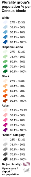
The maps "on the left" show the block-level race/ethnicity plurality patterns based on the 2000 Census. The maps "on the right" show the plurality patterns based on the 2010 Census. The legend next to the maps describes how the colors represent population percentages in each Census block. Special thanks to www.catchmyfame.com for the code to implement the comparison tool.
IMPORTANT NOTE: In blocks where the racial/ethnic group constitutes a plurality with a relatively low percent of the population, the block is shaded with a lighter color on the map. This indicates a more mixed population from a race/ethnicity perspective. Blocks with higher plurality percentages (darker shading on the maps) have a more homogenous population dominated by a single race/ethnicity group.
Note that mapping the plurality patterns may somewhat overstate the level of racial/ethnic segregation in some areas of the city. Even where the population is mixed, the maps only show one color shading. Another approach, such as "dot density" makes it easier to see the mix of population groups (for example, see the New York Times maps here). But it is easier to show change in density over time with color shaded Census blocks than with dots. We encourage your feedback and suggestions for improvement along those lines.
Click and hold the green slider in the middle of the map to drag the slider to the left or right so you can easily reveal the changing population patterns between 2000 and 2010.
- Dragging to the right reveals the 2000 map.
- Dragging to the left reveals the 2010 map.
- Click the links below each map to quickly show one or the other.
Also try our zoomable maps, allowing you to zoom in to specific blocks, click on individual blocks to see population details, and easily move around the New York City metropolitan region -- all while sliding back and forth to compare 2000 and 2010 race/ethnicity patterns on a block-by-block basis.
CONGRESSIONAL DISTRICT "BEFORE AND AFTER" MAPS
Comparing population patterns by block in 2000 & 2010
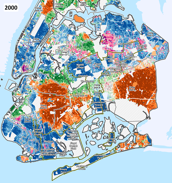
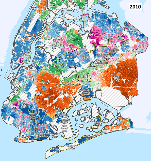
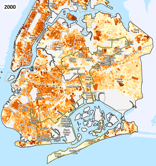
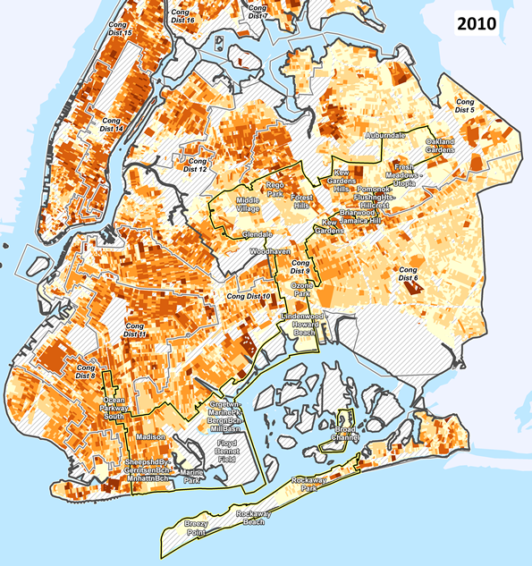
NOTE: Congressional district boundaries are from the NYC Dept of City Planning "Bytes of the Big Apple" files, pre-2012 redistricting. See DCP website for description.